


وصف لـ SatFinder
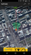
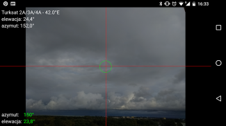
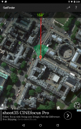
SatFinder (Satellite Finder) is a tool which will help you to set up satellite dish. It will give you azimuth, elevation and LNB tilt for your location (based on GPS) and chosen satellite from list. The result is shown both as numeric data and graphical on google maps. It has also built in compass which will help you to find proper satellite azimuth. It also can use augmented reality to show where is satellite on camera view.
Compass works only on devices with compass sensor (magnetometer).
How to use this app:
1. First of all, you should enable GPS and Internet on your phone. Remember – in most cases it is impossible to receive GPS signal inside buildings. So if you want to get very accurate location – please go near windows or go even outside.
In current app version location should be found quite immediately. So if you stuck with ‘no location’ message please make ensure that you got enabled all required features/permissions.
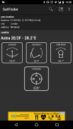
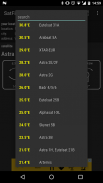
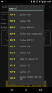
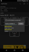
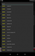
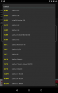
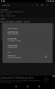
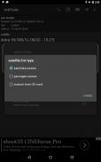
2. If app found your location, you must select desired satellite. To do this you must find icon with magnification glass and tap it. On the list you will find all satellites with elevation angle above zero degrees. Remember: satellite name doesn’t affect the calculation of angles. Important thing is satellite position.
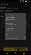
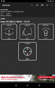
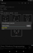
3. The azimuth, elevation and skew angle is calculated for your location and chosen satellite. Under calculated values there is a compass with graphical representation of azimuth angle. The azimuth angle is calculated with magnetic inclination. Remember – every time you use compass – you should calibrate it. Green line represents your phone azimuth. So if on compass green and red indicators are on each other – front of the phone should show you direction to the satellite. If the compass value is correct – phone azimuth value will go green.
SatFinder (الباحث عن القمر الصناعي) هو الأداة التي سوف تساعدك على إعداد طبق الأقمار الصناعية. وسوف تعطيك السمت والارتفاع والميل LNB للموقع الخاص بك (على أساس GPS) والأقمار الصناعية اختياره من القائمة. وأظهرت النتيجة على حد سواء كما البيانات الرقمية والرسوم البيانية على خرائط جوجل. وقد بنيت أيضا في البوصلة التي سوف تساعدك على العثور على السمت الأقمار الصناعية المناسبة. ويمكن أيضا استخدام الواقع المعزز لإظهار أين الفضائية على عرض الكاميرا.
يعمل بوصلة فقط على الأجهزة مع جهاز استشعار بوصلة (المغنطيسية).
كيفية استخدام هذا التطبيق:
1. أولا وقبل كل شيء، يجب تمكين GPS والإنترنت على هاتفك. تذكر - في معظم الحالات فإنه من المستحيل أن تلقي إشارة GPS داخل المباني. حتى إذا كنت ترغب في الحصول على موقع دقيق جدا - الرجاء زيارة بالقرب من النوافذ أو الذهاب حتى خارجها.
في الإصدار التطبيق الحالي موقع يجب أن يتم العثور على الفور تماما. حتى إذا كنت عالقة مع رسالة "لا مكان" يرجى التأكد تأكد من أنك حصلت على تمكين كافة الميزات / الأذونات المطلوبة.
2. إذا وجدت التطبيق موقعك، يجب عليك تحديد الأقمار الصناعية المرجوة. للقيام بذلك يجب أن تجد الرمز مع الزجاج التكبير واضغط عليها. في القائمة سوف تجد جميع الأقمار الصناعية مع زاوية الارتفاع فوق درجة الصفر. تذكر: اسم القمر الصناعي لا يؤثر على حساب الزوايا. الشيء المهم هو موقف الأقمار الصناعية.
3. يتم احتساب زاوية السمت والارتفاع والانحراف عن موقعك والأقمار الصناعية الذي تم اختياره. تحت القيم المحسوبة هناك بوصلة مع تمثيل رسومي من زاوية السمت. يتم حساب زاوية السمت مع الميل المغناطيسي. تذكر - في كل مرة تستخدم البوصلة - يجب معايرة ذلك. ويمثل الخط الأخضر السمت هاتفك. حتى لو كان على بوصلة المؤشرات الخضراء والحمراء هي على بعضها البعض - أمام الهاتف يجب أن تظهر لك الاتجاه إلى القمر الصناعي. إذا كانت قيمة البوصلة الصحيحة - سوف الهاتف قيمة السمت الى اللون الاخضر.


SatFinder - معلومات APK
نُسخة APK: 1.48الحزمة: com.esys.satfinderتطبيقات من الفئة نفسها
قد يعجبك أيضًا...


